UK/Ireland Marine Navigation Charts & Fishing Maps 86.0
Paid Version
Publisher Description


GPS Marine Charts App offers access to RNC charts covering United Kingdom / Ireland waters (derived from UKHO data) with POI layers created from ENC charts. Only marine GPS app to have route assistance with Voice Prompts for marine navigation. It has route manager to create new boating routes or import existing GPX/KML routes. It supports Nautical Charts course up orientation.
Please visit http://www.gpsnauticalcharts.com/main/uk-nautical-charts-by-folio.html for complete list. If you don't find the chart for United Kingdom / Ireland, please contact us at support at gpsnauticalcharts.com.
* Voice Prompts for marine navigation (requires GPS )
-prompts when approaching a boating route marker
-Continous distance and ETA updates
-Alerts when sailing/boating off route
-Alerts when boating in wrong direction
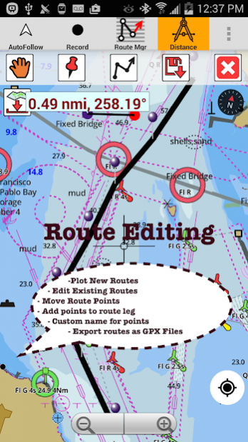
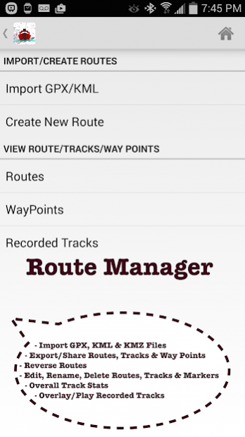
*Route Editing/Creation
-Create routes from scratch
-Edit existing GPX/KML routes.
-Add custom description to any route point.
-Drop markers along route.
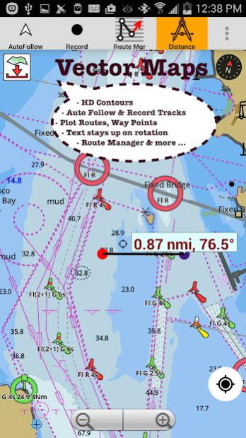
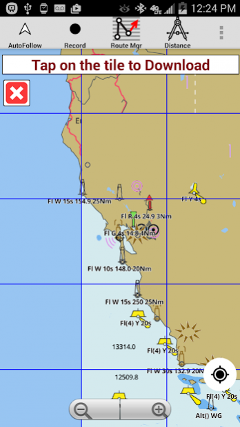
* Offline charts derived from UKHO data.
-Visually draw area to download
-Textual search
-Catalog (By state, region and coast guard district)
-Charts reprojected for WGS84 datum
*Seamless chart quilting of marine charts
*Distance Bearing tool
*Create custom way points
- Using GPS
-Select point on map
-Manually enter latitude & longitude coordinates
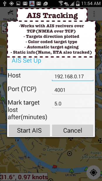
** Advanced NMEA Instrumentation
-AIS over TCP/UDP
-Wind speed, direction, temperature, depth, GPS over NMEA
*Pan/Zoom/My Location
* Record Marine GPS tracks
* View tracks overlay
* Live track animation
* Track analytics/stats
* Export GPX tracks.
-Export to SDCard
-Share GPX trakcs with friends/View on Google earth.
* Auto Follow Mode (Course up)
-Continuously updates boat's location on chart
- Adjustable update frequency
►Custom Base Map
√ Satellite/Aerial Imagery, Street Maps etc.
Sample Nautical Charts (please visit http://www.gpsnauticalcharts.com/main/uk-nautical-charts-by-folio.html for complete list)
The Solent and Southampton Water
A Beaulieu River
Western Approaches to The Solent
Approaches to Portsmouth
Bill of Portland to the Needles
Bill of Portland to Anvil Point
Eastern Approaches to the Solent
G Lymington River
A Continuation of River Medina
Southampton Water and Approaches
Outer Approaches to the Solent
Port of Southampton
Selsey Bill to Beachy Head
Approaches to Portland and Weymouth
Cowes Harbour and River Medina
Berry Head to Bill of Portland
A Entrance to River Hamble
Thames Estuary
B River Medina Folly Point to Newport
Portsmouth Harbour
D Ashlett Creek
H Yarmouth Harbour
F Approaches to Keyhaven
C Alum Bay
E Newtown River
Approaches to Felixstowe, Harwich and Ipswich with the Rivers Stour, Orwell and Deben
Falmouth to Plymouth
G Hillhead Harbour
Dartmouth Harbour
Poole Harbour and Approaches
Poole Bay
Falmouth to Truro
B Upper Reaches of Beaulieu River
Continuation of Fareham Lake
I River Yar
H Wootton Creek
Langstone and Chichester Harbours
A Lyme Regis Harbour
A Brighton Marina
Land's End to Falmouth
Portsmouth Harbour Southern Part
E Bembridge Harbour
A Continuation of Holes Bay
Eddystone Rocks to Berry Head
A Approaches to Padstow
Thames Estuary Northern Part
D Freshwater Bay
A Helford River Continuation to Gweek
Tor Bay
Portsmouth Harbour Northern Part
J Lizard Point
Continuation to Port Solent
Start Point to Brixham
A Continuation to Blackness Point
D Newquay Bay
Salcombe to Start Point
A Charlestown Harbour
Portland Harbour
River Thames Sea Reach
A Penzance Bay
Caernarfon Bay
Bristol Channel
B Mevagissey
Linney Head to Oxwich Point
Salcombe Harbour
Harwich and Felixstowe
Salcombe
Approaches to Falmouth
B Par Harbour
About UK/Ireland Marine Navigation Charts & Fishing Maps
UK/Ireland Marine Navigation Charts & Fishing Maps is a paid app for Android published in the Recreation list of apps, part of Home & Hobby.
The company that develops UK/Ireland Marine Navigation Charts & Fishing Maps is Gps Nautical Charts. The latest version released by its developer is 86.0. This app was rated by 1 users of our site and has an average rating of 3.0.
To install UK/Ireland Marine Navigation Charts & Fishing Maps on your Android device, just click the green Continue To App button above to start the installation process. The app is listed on our website since 2016-06-20 and was downloaded 80 times. We have already checked if the download link is safe, however for your own protection we recommend that you scan the downloaded app with your antivirus. Your antivirus may detect the UK/Ireland Marine Navigation Charts & Fishing Maps as malware as malware if the download link to com.skiracer.nautical_astore_uk is broken.
How to install UK/Ireland Marine Navigation Charts & Fishing Maps on your Android device:
- Click on the Continue To App button on our website. This will redirect you to Google Play.
- Once the UK/Ireland Marine Navigation Charts & Fishing Maps is shown in the Google Play listing of your Android device, you can start its download and installation. Tap on the Install button located below the search bar and to the right of the app icon.
- A pop-up window with the permissions required by UK/Ireland Marine Navigation Charts & Fishing Maps will be shown. Click on Accept to continue the process.
- UK/Ireland Marine Navigation Charts & Fishing Maps will be downloaded onto your device, displaying a progress. Once the download completes, the installation will start and you'll get a notification after the installation is finished.
